by Colin Ferster
We ran a mapathon in January as part of developing OSM Can-BICS, a national bicycling infrastructure datasat. The motivation for this mapathon was to provide an opportunity to collect community feedback on the map, and for our team to contribute some labour to OpenStreetMap (OSM), the datasource for our national dataset. This blog is a summary of the results and reflections.
Tools and approach
We promoted the mapathon on Twitter. We also had previously collected feedback (and recorded errors) from face validation sessions in seven Canadian municipalities with planners and technicians working for cities.
We built an ArcGIS Online app where people can draw lines where our national dataset doesn’t reflect what’s on the ground. There was also the ability to add points with free form text to explain any issues. We are lucky to have access and training for ArcGIS online from the SFU Library. The app was quick and easy to deploy.
Then we reviewed the contributed data and edited OSM following guidelines on the OSM wiki and de facto national standards from Bike Ottawa.
Results and reflections
The mapathon was a reminder of the vastness of national datasets! Every time I look at OpenStreetMap data, I appreciate the skill and dedication of OSM contributors. Our edits were mostly in western Canada where our team is located, and mostly in Vancouver and central Vancouver Island. Future efforts will be more strategic in identifying locations that need work.
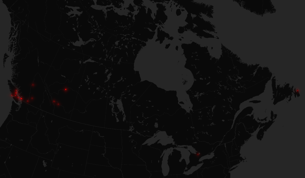 Figure 1. Map of edits (in red) contributed using the ArcGIS app, which we subsequently contributed to OSM following Bike Ottawa tagging guidelines. Basemap from CartoDB, data by OpenStreetMap contributors (2022).
Edmonton stepped up big time! We shared a map of downtown that had some obvious issues. It was a lot easier to untangle with local help. The detail of the contributed edits was impressive, and we feel a lot better knowing that the representation of downtown Edmonton is closer to reality.
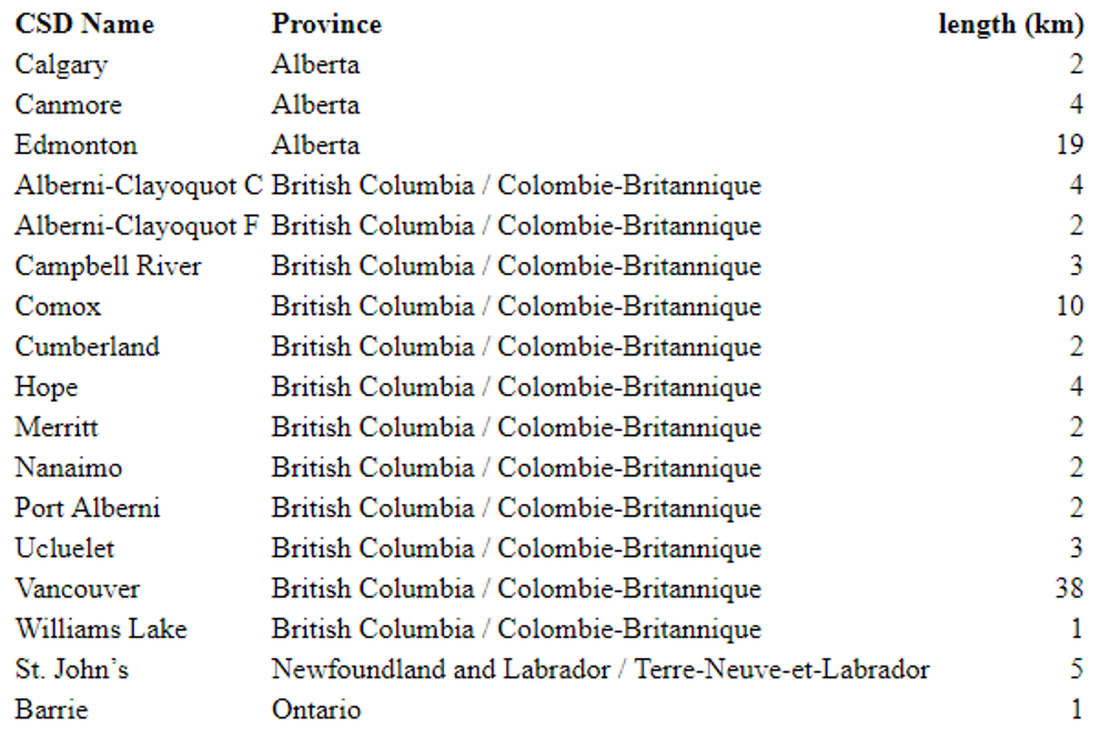
Table 1. Summary of edits by Canada Census Subdivision (CSD). Note that this underestimates the total distance edited, since it doesn't count the point comment edits, and incidental fixes (fixing intersecting paths and roads).
One of the issues we saw constantly arise is a lack of surface tags (e.g. paved or unpaved) on multi-use trails on OSM. We think this is an important tag for planning trips! Both for cyclists (what bike/tires do you need to ride there?) and for more general accessibility (gravel doesn’t work for everyone).
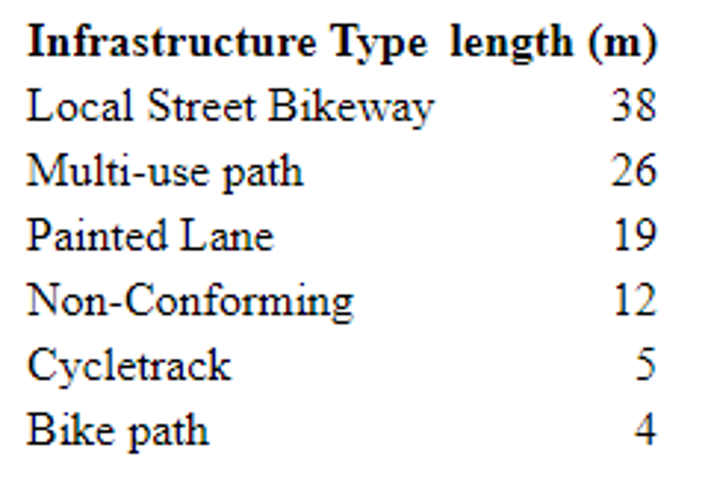
Table 2. Summary of edits by infrastructure type.
Additionally, OSM lacks resolution on roads with two lanes or fewer. There’s a big difference between local street bikeways with traffic calming and traffic diversion (common in Vancouver) and two lane roads with 50 km/hr limits. We know that few people pay attention to speed limits, but reduced speed limits combined with traffic calming and traffic diversion makes a meaningful difference. Note that local street bikeways are missing from the Bike Ottawa coding guidelines. My spring and summer mission will be adding traffic calming, surface tags for trails and paths, and pedestrian separation for bike paths.
During the mapathon, we learned about TriCityFix (maps here). This is a great example of what can be done with OSM, because OSM data span across multiple city boundaries. The TriCityFix app supports advocacy work. It also shows how consistent tagging practices (for example, following Bike Ottawa Guidelines in Canada) benefits multiple projects (Bike Ottawa, TriCityFix and Can-BICS all benefit from consistent tagging).
 Figure 1. Map of edits (in red) contributed using the ArcGIS app, which we subsequently contributed to OSM following Bike Ottawa tagging guidelines. Basemap from CartoDB, data by OpenStreetMap contributors (2022).


 (located near the top left corner of the map), and map what you know is currently on the ground.
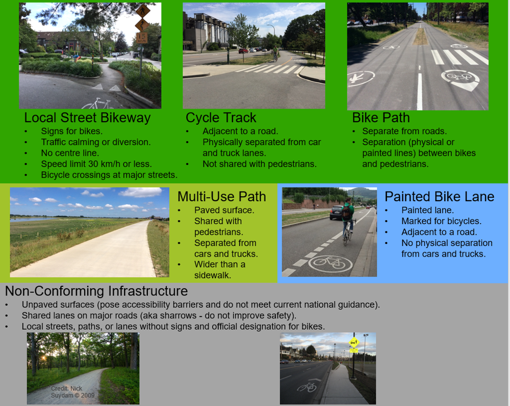 Figure 2. The
 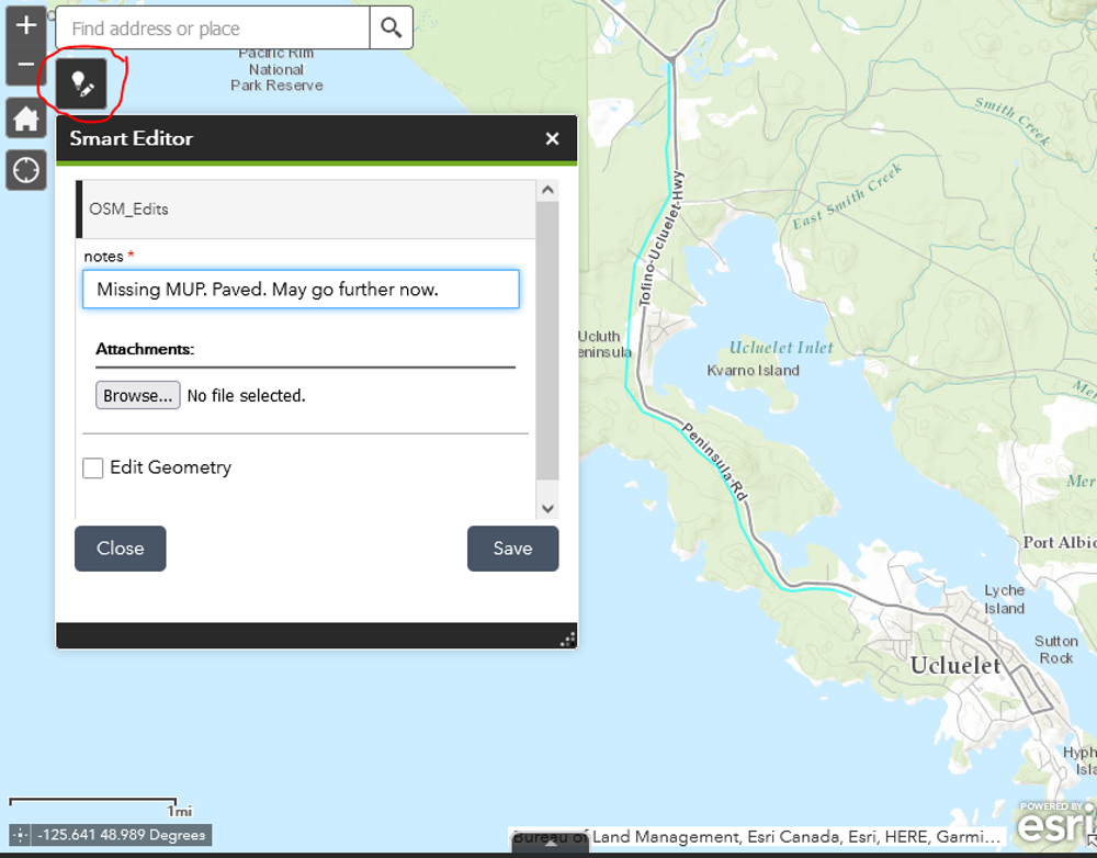 Figure 3. Here we digitized a missing multi-use path. We know that it starts at Forbes road, runs on the left side of the highway, and meets the Alberni Highway junction. We think it might go further now, but it has been a long while since we visited. Anyone know how far it goes? This is why we need your help!