A new report from the Pembina Institute found that cycling in Vancouver is quite safe when compared to other Canadian cities. It highlighted that while we have separated cycling facilities in the downtown core, a majority of the bike routes are “actually just signed routes on residential streets that are shared with cars”.
Yet any cyclist in Vancouver knows that some of these local street bikeways feel safer than others. One of the busiest local street bikeways is 10th Avenue, with over 500,000 cyclists each year. In the summer over 2,500 cyclists a day pass Clark along 10th Avenue. But 10th Avenue has a high number of cycling collisions relative to other corridors in the city, based on the City of Vancouver’s 2015 Cycling Safety Report.
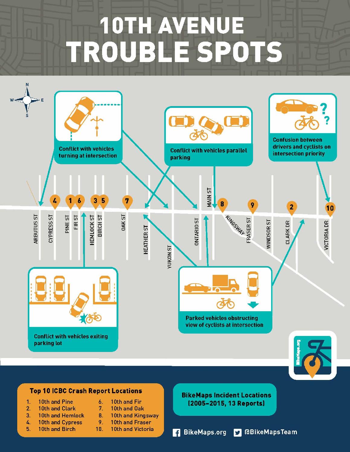
Mapping cycling safety data can identify where improvements are most needed. Our BikeMaps.org team looked at 128 ICBC-reported cyclist collisions (2009-2013) to identify the top trouble spots along the corridor and also BikeMaps.org data to understand the types of incidents that are happening. Conflicts with cars certainly stand out along the corridor – both moving cars and parked cars.

Luckily, the City of Vancouver has 10th Avenue as a priority route for upgrades to be more safe, convenient, comfortable and fun for people of all ages and abilities. Some changes have already happened, such as green paint to mark the intersection at 10th and Clark. If you want to know more about the City’s plans, their public consultation materials are here. You can also give the City feedback by writing to 10thAvenue@vancouver.ca. We will watch for their design plans in early 2016 and look forward to safer cycling!
About BikeMaps.org: This global online mapping tool was launched in Fall 2014 with the goal of capturing more data on cycling safety. It was developed by Dr. Trisalyn Nelson and the Spatial Pattern Analysis and Research (SPAR) Lab in UVic’s Geography Department. The BikeMaps.org Team includes Dr. Meghan Winters, a population health researcher from SFU. The MetroVan BikeMaps.org Team has received funding from the Bullitt Foundation to promote mapping across the Lower Mainland. With more locations pinned across Metro Vancouver, researchers will be able to document areas with cycling safety issues in the region. These results can be used by advocates and municipalities to identify priorities for infrastructure investments, resulting in streets safer for cycling.
Logging an incident is anonymous and only takes a minute or two. You can also receive alerts of any incidents on your route by creating an account. Both android and iOS mobile apps are available for citizen mappers to use BikeMaps on their mobile devices.
We welcome all feedback and interest in the project. Get in touch by email info@bikemaps.org, on Twitter, or through Facebook. Share a cycling photo on Instagram by tagging @BikeMapsMetroVan.