BikeMaps.org
  • Inicio
  • Visualización
  • Blog
  • Acerca de
  • Idioma
    • English
    • Español
    • Français
    • Íslenska
  • Invitado
    • Iniciar sesión
    • Registrar

BikeMaps Blog

  • Dic 16

    Holiday bike mapping - week 1 summary

    Dic 16
    Tweet

    Over the last week, we have identified priorities for holiday bike mapping:

    • Check the map for any changes.
    • Major roads.
    • Trail surfaces.
    • Bike (only) paths.


    We have already received some great feedback on the app! Thank you. This is exactly the help we needed. We will review these changes and update OpenStreetMap. The changes will show up in the new version of our national bike infrastructure dataset, the basemap of BikeMaps.org, and in other apps that use OpenStreetMap data, for example, Strava (note that they are updating their basemap in January), and there are many, many, many more.

    Thank you for the edits in week 1. This is exactly the type of feedback we are looking for. Week 1 edits.

  • Dic 14

    Mapping bike paths

    Dic 14
    Tweet

    Bike paths, which are not adjacent to roads and provide designated spaces for cycling (if well designed an implemented) are a gold standard in bike infrastructure. Especially on higher volume routes in larger cities. Painted lines or different surfaces, or physical separation using curbs can provide safe and comfortable places for people to walk alongside people riding bikes or using other forms of wheeled travel.

    Do these exist in your community? Are they represented on the map?

    The Arbutus Greenway is an example of a bike path where spaces are designated for cycling and walking.


    The Trillium Pathway in Ottawa has sections where seperate spaces are designated for cycling and walking.


    Another example of a bike-only path, found in Montreal.

  • Dic 13

    Mapping path surfaces

    Dic 13
    Tweet

    Today, the mapathon challenge is to check the map for hiking and mountain bike trails that are mapped as multi-use trails or bike paths.

    To a map reader, it’s intuitive that a trail plunging down a mountainside is unlikely paved, unless it says otherwise. However for a computer program reading the data, it’s more of a challenge. According to the latest version of OSM Can-BICS, Canada has more than 34,000 km of paths and trails with tags indicating that bicycling happens there. That’s a lot! There are many pushes to map recreational trails, bikepacking, and gravel routes. Many of these are missing the surface tag. While we love unpaved trails and we use desire lines to get us where we want to go, it’s important to add surface tags so that people who need solid surfaces can find them.

    As an example of why paved surfaces are important, in Vancouver, many people use the paved bikeway at Trout Lake to push strollers, as a solid place to walk, for their walkers, and for wheelchairs (note that the pathway is signed as a slow street, so the space is supposed to be shared. If we map these out - and the lack of places with hard surfaces to walk on - it helps the advocacy case for more space to ride separated from other modes).

  • Dic 12

    Mapping major roads

    Dic 12
    Tweet

    On the second day of holiday BikeMapping… Major roads.

    On the second day of Holiday Bike Mapping, we invite you to map scary bike infrastructure. Let’s add the number of lanes and speed limits to major roads that are presented as safe places to ride. We will map disappearing infrastructure at choke points, and debris strewn painted lanes.

    Motivated by a visiting colleague's recent perilous ride through Vancouver, we ask you to map places in your city, or a city you visited, that are terrifying to ride, despite having infrastructure. We are sorry to hear about these experiences, and we reflected on how this might have happened.

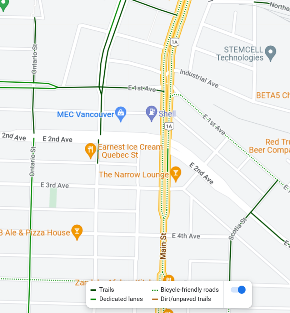
    For example, Main Street in Vancouver is a six lane road with faded sharrows, and while some people may choose to ride there (people certainly have a right to ride there on a public road, if they choose), we think people should know what they are getting into. You shouldn’t need local knowledge to pick a safe route using widely available tools. Google Maps actually lists South Main Street as a bike-friendly street. The street is also listed as legacy bike infrastructure in Vancouver’s open data. The location has high betweenness-centrality (to get between many points in the city, you have to squeeze between the water and the train tracks and there are only a few roads going through there), so that might contribute to why some routing algorithms are sending people to ride down Main Street during evening rush hour in the rain!

    Screen Capture from Google Maps on December 12, 2022. Main Street is mapped as a "bicycle friendly route". South Main Street in Vancouver on Google Maps


    On OpenStreetMap, Main Street is well-attributed since it is mapped as a primary road with six lanes, a 50 km/h speed limit (not that anybody follows it!), and a shared lane for bikes. Given that information, some people may chose a different route. On OSM Can-BICS it's mapped as a non-conforming major road. This helps us for safety studies because we can study what types of incidents happen at places like these. Other tools that use level of traffic stress calculated from OSM data will also take this into account and assign weight in routing algorithms.

    For today's mapping challenge, check the OSM Can-BICS map check that major roads are mapped as "non-conforming major roads", that they aren't missing, and they aren't misclassified as "local street bikeways".

    Non-conforming major roads have officially designated infrastructure that is not physically separated from traffic (sharrows or painted lanes) and meet any of the criteria below:

    • speed limits above 30 km/h
    • absence of traffic calming or diversion
    • more than two lanes
  • Dic 6

    Mapathon - introducing Can-BICS v3

    Dic 6
    Tweet

    by Colin Ferster

    Version 3 beta of the OSM Can-BICS dataset is now live on ArcGIS Online. We invite you to use the app below to submit feedback that will be reviewed by our team.

    Are changes to infrastructure represented in the new version? Is anything important missing or incorrect?

    Zoom in to the map below to review and add points or lines with descriptive comments. Often a point comment is all it takes to get the point across. We will review the comments and edit OpenStreetMap. You can use the embedded app below, or open the app in its own window to get more screen space.

    We will update the OSM Can-BICS dataset in early January to match updates in the Strava Metro dataset.

Older posts »